A Good Night’s Sleep, or Would we regret this for the rest of our lives
The night before Half Dome we got stuck with a snorer. Normally you don’t have to worry about who is lodging next to you, because you’re in a nice, well-insulated and semi sound-proofed facility such as those found at Yosemite Lodge or the Ahwahnee. But as finances would have it, a multiple night stay at the Lodge or Ahwahnee would have cost us $98 or $250 a night, respectively, so we settled with a canvas tent cabin at Curry Village for $48. Imagine a colony of cabin-shaped canvas tents seated three feet apart from each other and you’ve got Curry Village where you can hear every word, every creak, and certainly every snore from any number of your immediate neighbors.
This snorer of ours was not the kind of considerate snorer who starts a little, stops a little, maybe someone rolls them over onto their side, and then you forget about. This was a solid snorer who would be at it the entire night – in 45 minute segments with about a two minute breather before restarting the whole process. So if we didn’t manage to fall asleep in those fleeting precious minutes, it was another 45 minutes of relentless horror and panic until the next break.
All this without even mentioning the fact that Mary was just over four weeks pregnant with our first child and had just begun suffering the nauseating attacks of morning-noon-and-night sickness. Just wonderful. Not only were we not going to get any sleep the night before the greatest physical achievement of our lives, but all night I was thinking, If we don’t get any sleep, and Mary’s as sick as she’s been this past week, we’re lucky if we can get past breakfast much less anywhere near Half Dome. This is bad.
It must have been sometime between 3:30 and 4 in the morning when we finally fell asleep, giving us about an hour’s rest before the sunrise and two hours before the alarm would ring. God was watching, because somehow come morning we felt rested and ready for the day’s journey.
June 5, 2001:
Hiking Half Dome, or Would we regret this for the rest of our lives, Part 2
To reach the summit of Half Dome and make the return trip in a single day, you’re looking at 17 miles and 10 to 12 hours of pure persistence and will. Lucky for us, it was two weeks to the Summer Soltice, giving us a sunrise at 4:42 AM and sunset at 9:10 PM. Perfect.
Waking at 6 AM, we got over to the Yosemite Lodge for breakfast just after 6:30. Our reason for having breakfast at the Lodge was simple – it opened a half hour earlier than Curry Village’s cafeteria and it didn’t force us to pay $8.95 per person for a buffet that we wouldn’t be hungry enough to take advantage of. The Lodge has a good variety of pastries and cereals as well as American breakfast staples such as bacon, sausage, eggs, toast, pancakes, French toast, oatmeal, cream of wheat, fruit, coffee, and orange juice. Mary took the oatmeal – one, because she likes it, and two, in an attempt to settle her stomach and stave off any nausea that might want to creep into her day. I opted for scrambled eggs, sausage, and a cup of coffee.
Preparation
Here’s a list of what we took with us on our hike:
• 2 sandwiches (purchased from the Lodge Cafeteria the night before and put on ice overnight – we later found out that the Lodge has these sandwiches ready by breakfast, so we didn’t have to pre-purchase them the night before)
• 4 liters of water (in a Platypus hydration pack inside our daypack)
• JanSport daypack
• 4 servings of Gatorade powder
• 1 plastic wide-mouth liter bottle, empty (for replenishing water supply)
• Iodine tablets and iodine neutralizer tablets for water purification
• 3 baggies of trail mix
• 2 hiking sticks with steel points (essential for average hikers like us)
• Comfortable hiking shoes with good support and traction (essential for avoiding blisters – which we did)
• Trail description and map from the Falcon guide to hiking Yosemite
• Total Pack Weight: approximately 30 pounds (we over-did it, but more on this later)
Vernal and Nevada Fall
Shuttles in Yosemite Valley begin running at 7 AM, so if we were at our most efficient, we would have finished breakfast and arrived at the Happy Isles shuttle stop and trailhead by 7:15. We would not be so nimble this morning. Somehow we had managed to burn an extra hour eating and making sure we had everything in our daypack. By the time we disembarked the shuttle and started out from the trailhead, it was 8:35 AM. The latest food service in the Valley is the Curry Village pizza place that closes at 9 PM. The Curry Village store closes at 10 PM, but who wants a cold, plastic-wrapped roast beef sandwich and Doritos after a 12-hour hike? Not us.
Starting out wasn’t bad at all since we had done the first mile to the Vernal Fall footbridge six months ago on our first trip to Yosemite. The trail is paved most of the way and just as we felt like we needed to take a quick rest at the top of a steep slope, the trail dipped and suddenly we were at the footbridge. The falls were in full swing with cold snowmelt cascading down and flowing beneath the bridge. There’s a drinking fountain at the other side of the bridge, but we hiked on since I was already lugging four liters on my back.
Just a few steps past the other side of the bridge the trail splits on its way to Nevada Fall – to the left is the Mist Trail and to the right is the John Muir Trail. We headed up the John Muir Trail. It’s about a mile longer than the Mist Trail but has the distinct advantage of not being nearly as steep or grueling. The Mist Trail takes you alongside both waterfalls, a cool, wet, and refreshing option if all you’re doing is the falls, but we don’t recommend it if your ultimate goal is a single-day Half Dome ascent and return; you’ll see why a little later. The John Muir Trail is also known as the horse trail, which means it’s a better maintained and less steep trail and it also means you may have to give right of way to tour groups on horseback and park rangers moving supplies by mule, not a big deal.
So it was onward and upward. The trail felt like endless switchbacks and for a while it felt like we were going in the wrong direction. We just happened to be hiking about a hundred feet behind an elderly woman with two hiking poles, the ones that look like ski poles. We finally caught up to her at Clark’s Point where she told us we were going in the right direction. After all, it turned out she had already hiked up Half Dome three times!
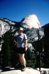 Clark’s Point was an incredible milestone (an infamous milestone as you will see) for us since the view is the first sign that all the struggle was going to be worth it. Nevada Fall was spectacular from here, pouring over a 594-foot solid rock cliff side. Above and left of the falls was Liberty Cap, a stunning black cone of rock and trees. And farther to the left was the brightly lit backside of Half Dome. We stopped to take a couple pictures. Clark’s Point is also the junction for a side trail connecting the John Muir Trail to the Mist Trail. This connector climbs down the canyon and meets the Mist Trail near the top of Vernal Fall.
We ascended more switchbacks on the John Muir Trail. Then we came to a nice section of the trail that was cut into the side of a cliff. Seasonal water trickled down from above and gently sprinkled us as two park rangers and their pack mules passed us on their way back to the valley floor – they were bringing down trash and used supplies from the ranger station and campground in Little Yosemite Valley. This trickle of a waterfall along the trail was both refreshing and a little dangerous in how it created a slippery rock, puddle-jumping situation for us. The trail goes up a little more then drops down to the top of Nevada Fall. A footbridge crosses the river about 50 feet from where the water plunges over the edge. We stopped to have a snack on some rocks on the far side of the bridge, careful not to accidentally feed the scavenging squirrel who sat beside us.
Little Yosemite Valley
After some stone-cut, switchback stairs among boulders just above Nevada Fall, we emerged into Little Yosemite Valley. It’s a serene place with the Merced River easing by on our right amongst the trees and tall grasses, but it’s nothing of the majesty associated with it’s bigger namesake. Although Liberty Cap looms to the left, there are no other massive rock formations like in the main valley, no Half Dome, no El Capitan, no Glacier Point, but likewise, there are no paved roads carrying the constant flow of cars and exhaust fumes down and around stream. A quiet settles on the meadow and one can almost hear, or at least imagine, the rustling of a black bear foraging for berries or attempting a mid-day food canister break-in. But, thankfully for Mary (and therefore myself), no such bear would announce its presence.
The flat-bottomed valley allowed us to see distant trails that more or less paralleled our own, a cause for time-to-time worry since we were never quite sure if we should have been on this or that trail. And having made it this far up toward Half Dome, the foot traffic dropped off considerably, diminishing our ability to play follow-the-leader to the top with other hikers. We had either lost the less-hardy day hikers to the roaring excitement and accomplishment of Nevada Fall, or we were a disheartening three to four hours behind our Half Dome summitting counterparts who chose to hike up to and camp overnight in Little Yosemite Valley the previous day and were now happily catching the view from the top while we trudged upon their morning footprints.
Climbing the Shoulder (the “Saddle”)
The way the trail goes, our goal, Half Dome, kept dodging in and out of sight behind closer hills, then it would move from front to back to left to right as the trail twisted around, and that worry of being off course reemerged. So we kept looking out for signs that we were still on the right track. Quickly, however, we began to see hikers going the other way, people we assumed had made the glorious summit, taken their requisite pictures, and were returning to their home bases for a pleasant meal and rehashing of their adventure. The sight of these fellow human beings was both encouraging – no one has died or suffered some horrendous injury – and maddening – in the sense of “why are we still going in this direction!”
Soon enough, we came upon a wooded area and a sign, yes, a sign! “Half Dome: 2 Miles.” We took this moment to sit a while and finish the half-eaten sandwiches we started at Nevada Fall, a refueling top-off before we made our final ascent and joined the “MADE IT TO THE TOP!” club, enabling us to purchase without guilt innumerable trinkets, t-shirts, key chains, hiking medallions, playing cards and various other items from the Yosemite Village gift shop. Of course, if it were up to me, we wouldn’t have stopped to eat at all – no matter that my toes were really starting to hurt and pinch, and my left knee was showing signs of serious wear. We were two miles from the top, for goodness sake! Mary put some sense in me, however, so we stopped for a much-needed meal and rehydration moment.
At this point the trail dirt became an almost rust color as the trees seemed to become shorter. It felt like we had entered the red rock region of Sedona, Arizona, rather than being 8,000 feet above sea level in the Sierra Nevada. Then the trail plateaued and opened up a wide view of our next challenge. I wish I could say it was our final challenge and that the view that opened up was of the dome itself, but it wasn’t. The great granite dome had almost completely disappeared behind a massive granite rock pile into which trailblazers had carved and set the most reckless, devilish switchback staircase imaginable. We were at the base of the shoulder, which I found out later is actually called “the saddle,” but at the time we didn’t know any better, nor did we care. What we’re calling the shoulder is the hump just to left of Half Dome when viewed straight on, looking directly at its sheer face.
Only three to four flights up the switchback staircase, I quickly realized what a pounding my knees had taken. With each step up, I could feel the tendons and ligaments fighting and scraping against too-tired bone. My hiking stick was my savior as I tried to alleviate some pressure by transferring the weight to my as yet unused arms. We witnessed at least one 20-something man summarily succumb to the increasingly dizzying heights, turn, and trek back down the stairs, within just a mile of his and our final goal.
The last segment up the shoulder, following the stair climb, was a comparably easy, though sometimes hand-and-foot, scramble up bare granite to the top of the shoulder. It was the perfect, and absolutely necessary, rest stop before make the final ascent. After all, it’s hard not have your breath taken away at the sight of Half Dome after having survived the granite stairmaster. The dome rises bold and solitary with nothing to serve as its backdrop except cloud and sky. Then with an unbelieving squint, we saw the set of ever-narrowing cables fastened directly into the northeast side of Half Dome as it leads up to the top. This pair of parallel cables are about five feet apart with two-by-four wood planks spaced horizontally every five to six feet up the 60-degree face that feels like it’s almost straight up. The cables are the hiker’s lifeline for the final 800 feet to the top.
Final Ascent: The Cables
We’d come this far, and while we knew there was no way we could even consider not making the climb to the top, doubts intervened and made us wonder if we had anything left after five hours, eight miles and four thousand feet of elevation invested. We each took in an energy bar and approached the Half Dome cables with growing awe and respect for the towering monolith.
At the base of the cables was a cardboard box of gloves. These gloves, a gift from hikers who’ve gone before us, are crucial if you have any desire to leave the skin on the palms of our hands intact after making the summit. Every winter, at the end of the “safe” Half Dome climbing season, the park rangers remove the cables and collect all the gloves hikers have left for one another and store them until the beginning of the next climbing season – usually the end of May or beginning of June when the snow has melted off the main trails and it’s once again deemed safe enough for the rangers to reinstall the cables and leave the box of gloves out for another round of hikers.
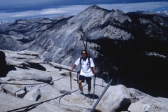 This final 800 feet of climbing now felt like the easiest part of our climb. Sure, a slip here or there could easily buy an express trip straight down to the valley floor where this all began, but the necessity of absolute concentration on one step after another shuttered our vision from everything except the task at hand. Our only focus was making constant forward progress: the grip on the cables, the distance to the next foothold, pulling with the arms, pressing firmly with the legs. About as many times as I needed to stop and rest, holding firmly to the cables while standing aboard a wooden plank, I also needed to wind my way around and past a fellow traveler finding similar rest elsewhere on this Jacob’s ladder. Though I envied those already on their way down, my only desire was to move upward to the top.
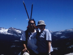 From the top of Half Dome, the valley floor was like a hazy miniature golf course. The roads were almost imperceptible, and the bungalows of Yosemite Village were like tiny brown jewel boxes amongst broccoli and toothpick trees. Here, the best views are not of the place you’ve come from, namely the beautiful Yosemite Valley, because what makes the valley so beautiful in the first place is what is above the valley floor, the soaring heights of El Capitan and Half Dome, the majestic rains of Bridal Veil and Yosemite Falls. The valley is beautiful for what is up, not what is down, which is all you can see of the valley now four thousand feet below. The true beauty here is beyond the valley, looking northeast toward the clean slopes of Clouds Rest and especially to the south where the incredible Sierra Nevada range explodes in snow-capped peaks, one after another a hundred times over. It’s easy to imagine that somewhere past the horizon, 200 miles south on the John Muir Trail, sits Mount Whitney, the state’s tallest mountain, nestled among the giants at Sequoia-Kings Canyon National Park.
Getting Back Down
Making the return trip would, on the surface, seem a simple endeavor. Just wind up the ball of string and retrace our steps back to camp. If only we’d had that line of string to ball back up. But we’ll soon get to that part. First we have to get back down those cables.
The easiest and fastest, and probably the safest, way off the summit is to squat with your rear against your Achilles and the soles of your shoes pressed firmly and flatly against the granite surface. Holding onto the right-hand cable (because you must leave passing room on your left for those still on the ascent), let yourself slide down to the next plank. If you continue doing this all the way to the bottom, you’ll find you’ve expended almost no energy at all, allowed yourself very little time to become frightened of the ridiculous heights you’ve gotten yourself into, and without even realizing, you will have made it back to the shoulder in about ten minutes, three times faster than it took to go up.
On our way down the slope, we managed to befriend a fellow hiker whom we decided to accompany back down to the valley. She had come up on her own after her companion bailed much earlier on the trail up and we didn’t feel right letting her go the rest of the way alone. Our bit of Samaritanism, however, would eventually put us in a bind and blind rush to get back to camp. Her slower pace was incompatible with our desire to return to camp in time for dinner. This was extremely important since Mary was four weeks pregnant and needed to have a proper meal by day’s end. As noted before, the pizza stand at Curry Village closes at 9 PM and it was already past 3:30 PM. From our calculations, we would need every bit of the five and a half remaining hours to make it back to the trailhead to catch the shuttle back to Curry Village in time.
At Little Yosemite Valley, the shadows were noticeably longer than we had last left them there, but retracing our steps wasn’t so bad. We had run out of water, but came across a stream that we used to refill our bottles (treating the water with the purifying tablets and mixing it with the Gatorade powder to mask the iodine taste). The snow-cold water was refreshing beyond compare. Soon enough we were back at the switchback stairs among the boulders just above Nevada Fall and that’s when my left knee began to really act up. Stairs were the real killer as my knee was no longer willing to accept the weight of my body and backpack. The hiking stick only shifted a negligible amount of weight off that leg, but I knew we had to get back, after all, what other choice did we really have.
At Nevada Fall we had the choice of retracing our steps back down the John Muir Trail from whence we came or follow the lead of our new hiking companion and branch off onto the Mist Trail that follows the Merced River back to Vernal Fall and the trailhead. We went against our own experience and followed her down the Mist Trail, a choice we’d quickly discover to be the biggest misstep of our journey. Since the trail runs alongside the Merced River and the trail is taken from a point above Nevada Fall, it means that we would have to somehow descend into the canyon almost as quickly as the river plunges down the fall. Simply put, an incessant stair system, as devious as any we’d seen to this point, would take an almost final toll on my knee. By the time we thought it might have been better to take the John Muir Trail, which has no stairs, we’d already come down a third of the way and the idea of backtracking up the stairs seemed too wasteful to consider. So we hiked on down the Mist Trail, fully anticipating the refreshing spray that gives this trail its moniker. We were feeling the sun lowering before us so we picked up the pace a little, leaving our companion just about two switchbacks behind at any given time, always within yelling distance. We were determined to make it back for dinner. We moved quickly onward, looking for any sign of the mist. But this mist we would never feel nor see because somewhere along the way we missed a sign and fork in the trail. Before long we found ourselves quickly climbing back out of the canyon, farther and farther away from the river and the promised refreshment of the Mist Trail.
Mary said, “this is going to take us back to that place.” That place? What place, I wasn’t sure. But after a dozen more switchbacks it became disturbingly clear as to what place she was talking about – Clark’s Point. Basically we made the terrible stairway descent into the canyon only to climb back out and onto the John Muir Trail again. With at least an hour lost, and priceless drops of energy and knee cartilage also lost, we dutifully pressed on, at times breaking into full sprints to beat the sun down. The air was beginning to cool and the tall trees made the sun seem like it was setting two hours early; the high walls of the valley didn’t help any. A panic fell on us both – Mary panicked that we’d be bivouacking in the woods among starved black bears, and I panicked that I, our trail leader and self-designated map boy, might not really know where we were going after all, no matter how much I tried to convince her that we were on the right track. It turned out that even though we were making the return trip on our previously traveled John Muir Trail, I had once again missed a sign and fork in the trail and completely bypassed Vernal Fall and the footbridge. Soon we were in completely new territory, on a completely different trail than we’d ever seen or known about. The map I had showed no other trail than the one we used to go up. As long as I kept the Merced River on my right, I thought to myself, we would make it back to the valley, because that’s where this river goes! Of course I had no clue if this trail would take us back home. I had no idea if the trail would suddenly veer back into the mountains without leaving us the option of continuing along the riverside. Soon we were hopping over streams that spread out from the Illouette River as it connects to the Merced. And a brand new fall, the Illouette Fall, could be heard and eventually seen on our left. An interesting diversion for sure, but certainly not a diversion we were supposed to see on this trip.
Thankfully, someone was watching us from above because eventually the trail came to a green water tower and turned into a wide, paved service road. Finally, signs of civilization. My knee was still crippling me as I hobbled along, but hope had reentered my soul as a familiar grove of trees, a restroom and a small nature center came into dim view. It was the Happy Isles trailhead. The sun, though still an hour from sunset, had dropped below the opposite valley wall, casting the shadow of night throughout the Yosemite Valley. It was 8:20 PM.
Now we had nothing more to do than wait for the next shuttle to pick us up and whisk us back to Curry Village for a well-deserved pizza dinner. But after five, ten, fifteen minutes, no shuttle showed up and we were starting to wonder if we should have walked back to camp instead. Walking, however, would have taken us another half hour, making us too late for any chance at a hot dinner. The group of tired hikers waiting for the shuttle was swelling to quite a large following. A group that had been at the stop before us said they’d already been waiting ten minutes before we arrived. We were starting to lose hope in the shuttle ever arriving, and that pizza dinner was growing colder and colder in our wishful memory.
Then the lurch and grumble of a distant diesel engine could be heard above the soft wind in the trees. A pair of dim yellow headlamps darted in between tree trunks and the engine noise played its sweet tune as the shuttle, really a bus, pulled out of the darkness and to our stop. 8:40 PM. All hikers boarded and the look on all our faces was the same, it was something of not quite elated triumph and not quite exhausted defeat, but rather a peaceful, solemn satisfaction. The driver asked if there was anyone else who needed to board since his was the last shuttle of the night, news that came as a shock, surprise, and relief all at once. We told the driver about the girl who was hiking back down with us, and others in the bus mentioned having passed her along the Mist Trail and having seen her near the Vernal Fall footbridge, which was only a mile from the trailhead. We waited about five more minutes as some more hikers trickled into the bus, but nowhere to be seen was our prior companion, so the driver restarted the engine and we growled away from the trailhead.
Pulling up to the Curry Village stop, it was five minutes to nine. We made it. Greasy pepperoni pizza and a pitcher of root beer never tasted better as we sat outside on the crowded patio with scores of other hikers, slipping off our boots, wiggling our toes in freedom, and finally taking the time to recount the day’s conquest.
Later that night, as we waited outside the showers for our turn at cuddling up to godliness, we once again came across our once-lost hiking companion. She made it back to camp about an hour after we did and luckily had some friends who saved her a little something to eat. We swapped stories on how each of us completed the final leg of the trip and how we were actually glad, in a strange sort of way, to have become misdirected the two times that we did. She told us the Mist Trail, as darkness began to fall, was extremely slippery, damp, and cold near Vernal Fall, a combination that would have wreaked certain havoc on my ailing knee. And the original trail between the trailhead and the footbridge, which includes a quick but steep incline before descending back to the valley floor, also would have spelled bad news for me. The John Muir Trail, which we ended up on, was much more kindly graded for the horses that usually tromp this way, and it was even paved for the final portion. Of course we could have avoided much of the agony if we had simply stuck with the John Muir Trail from beginning to end instead of testing out the Mist Trail. (Note to self and others: Bring a trail map that shows all the area trails and not just the trail you’re supposed to be on, because once you’ve veered off course, it’s impossible to know from a singular black squiggly line if you’ve missed a fork in the trail.) Regardless, it was a relief for us all to know that we all survived to speak of our Half Dome triumphs for many years to come.

4 comments:
Wonderful! I was at Yosemite couple of years ago. I wouldn't venture a trek to the half dome! I am 68! But the beauty of the face of the half dome on the west side was wonderful to look at during sun set! Hope you might have enjoyed this too!
hi, did your wife exercise regularly prior to her getting pregnant? it's great that she was able to hike despite her condition.
Yes, she did. We were actually kind of readying ourselves for a half-marathon which never came to fruition. But the hike of our lives did!
Enjoyed your comments. I made that hike in 1963 while I was in the army. My mom, dad and two brothers made the climb. Don't think the John Muir trail existed then and my Dad had knee problems on the decent by the falls trail. Truly a memorable experience. We had to help a young fellow down Jacob's ladder who had frozen with fear!
Post a Comment