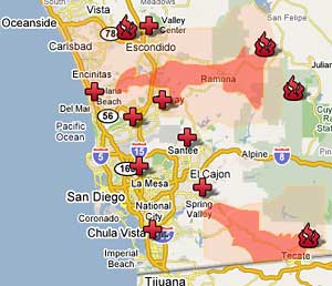
The toll (as of 2PM TUESDAY): 1,250 homes & 241,000 acres burned.
For updated information about the fires in San Diego check out the following links:
KUSI (local news, has a live video feed online)KGTV (local news, live video)San Diego Union-Tribune (newspaper)Here's our story so far:
SUNDAY: We celebrated Jackson's 4th birthday one day early with a day at LEGOLAND. Since it's also the Halloween season, LEGOLAND was having a "Brick-or-Treat" event for kids to get candy, coupons for free ice cream, healthy snacks like fruit, and Lego related stuff. Both boys dressed up as Underdog. We invited another family to come along with us to celebrate, since Jackson absolutely adores their kids, especially their 4-year-old girl, Summer. As we left the park at 4pm and started driving back home down I-5 from Carlsbad, we entered a huge smoke cloud drifting toward Del Mar like a backward fog. This was the first time we became aware of any fires going on whatsoever.
This smoke was from the Witch Fire that started out in Ramona (toward Julian). We quickly heard of yet another major fire in San Diego, the Harris Fire that started in Potrero right near the Mexican border to the east of us.
MONDAY: Jackson officially turns 4. The Santa Ana winds, which started Sunday, blew hard and steady all night long and by the time we saw the news Monday morning, the Witch Fire to our north had blown into Rancho Bernardo and was threatening to cross I-15. Homes were already burning. The Harris Fire was moving steadily east toward Jamul. But really, this morning we had no idea just how big or bad or where any of these fires really were. The high winds kept all air support grounded, so the only way we knew of the fires' advancement was by residents calling in to the news stations reporting that houses were on fire.
After seeing the damage of the fires from 2003, we weren't taking our chances. Mary went to work to see some nursing home patients who were really sick while I loaded up the car with the kids, photos, clothes, and Legos(!). By 10am I was on the road headed for mom & dad's place in Huntington Beach. 2.5 hours later we arrived and just hung out inside since there was also smoke in HB due to an arson (don't even get me started!) fire in Irvine.
By nightfall, Mary called and said things were looking pretty good back in El Cajon - clear skies, very little smoke, and the fires to our north and south and not heading our way. So I repacked the car and drove back home. Meanwhile, Mary unpacked her equally loaded car she'd packed just in case she was going to evacuate.
After grabbing a late night dinner, I headed back out to check on the progress of the Harris Fire. Driving out from our home, up and over Vista Grande Road, I saw Mt. San Miguel outlined in orange and red flames directly to the south. The entire south face of the mountain was on fire (we live about 7 miles north of the north face, which I'm looking directly at), including Proctor Valley on the other side. So the Harris Fire had basically moved over 20 miles west from its origin and was heading straight for Otay Lake Reservoir, Chula Vista, and Spring Valley. The winds were still very strong, but blowing due west (remember, we're to the north).
Despite being able to see from right near our house, we felt relatively safe to stay the night.
TUESDAY/TODAY: The Harris Fire seems to have stalled in Proctor Valley, though still very much threatening Chula Vista's Eastlake neighborhood, Spring Valley, and La Presa. I can't even see Mt. San Miguel today due to all the smoke. Since we'd been boxed indoors all day yesterday, not to mention the total of 5 hours on the freeway, I really needed to get the kids out of the house today. We headed off for Toys-R-Us in La Mesa to buy Transformer toys for Jackson thanks to the gift cards and cash the two sets of grandparents and his aunt gave him. We then drove over the Parkway Plaza and Best Buy only to find the parking lot in front of Borders/Best Buy had been turned into a horse corral. Some 50+ horses and ponies had evacuated here, including their owners and their families. There were also lots of dogs and even a group of 10 goats. These were all evacuees of the Harris Fire.
Today we've still got blue skies all around and very little smoke in the air. To be safe, however, we're staying indoors all day. It's a blazing 97-degrees outside, so even without the smoke, we'd still be indoors.
In the meantime, the Witch Fire has moved both west and south - as far west as Rancho Santa Fe, having jumped I-15 and moved across the north edge of Rancho Penasquitos, and as far south as parts of Lakeside now. Evacuations have been ordered clear to the Pacific Ocean! So far, however, the fire's stalled around Rancho Santa Fe and has not yet reached I-5.
That's it for now, feel free to call or email, or I'll try to keep you all updated if things change.
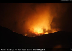 Mt. San Miguel on fire (Harris Fire), photo taken from intersection of Steele Canyon Road and Highway 94 at 8:40 PM, Tuesday, 10/23/07
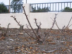
 Anyone who's ever grown roses of their own knows full well that roses are not in season in North America during the month of February. In fact, it's in January or February of each year that most gardeners prune and defoliate their roses - some, almost clear to the ground. So along comes this tradition of giving your sweetie a beautiful bouquet of roses on Valentine's Day, only to find that the prices are insanely high due to the fact their they're all imported from either South America or Africa!